
YOUR GUIDE TO
Snorkelling the Batemans Marine Park
There are some limitations on our activities at the moment but we recommend - as a form of much needed exercise for body and soul - you should still make the most of the clearer, calmer and warm waters.
Therefore, we have put together some snorkel guidelines and a list of known or possible snorkel spots for you to explore in the Batemans Marine Park.
If you do go snorkelling please send any reports, comments and feedback from the places you visit. Our list of snorkel sites can be refined with further information from you, our members and supporters. If you have any photos or descriptions of critters you want to identify or know more about, send them to info@ncmg.org.au and we will attempt to enlighten. And please share any photos and brief comments on our Facebook page.
Enjoy the warm water and exploring our wonderful diverse marine life.
The sites are rated (Novice, Intermediate, Advanced) to give an indication of the ability required for safe snorkelling at each location. The ratings are made assuming favourable conditions (light winds, calm conditions, minimal current). Anywhere can become unsafe in poor conditions, so take care and snorkel safely.
Snorkel Spots
MOSQUITO BAY
Ability required – novice
How to get there - The car park is accessed directly from George Bass Dive, just north of Malua Bay. Easy entry from the boat ramp or the pebble beach.
Conditions - The bay inshore is relatively sheltered from all but the strongest easterly winds. More exposed to ocean swells further out.
What’s there - Keep an eye out for large black rays patrolling in front of the fish cleaning table. On the south side the bottom is rubble formed from ballast dumped from cargo ships years ago, with not much fish life. The north side comprises a series of rocky ridges with gutters in between with good kelp cover and fish life. Some urchins in the reef crevices.
Facilities - Picnic table, toilets and café next door.
GARDEN BAY
Ability required - novice
How to get there - This small bay, the next one south of the boat ramp at Mosquito Bay, can be reached by following Iluka Avenue. Take the first turnoff from George Bass Drive towards the sea on the southern side of the boat ramp and drive to a small carpark just behind the beach at Garden Bay.
Conditions - The bay is fairly exposed in north-easterly and easterly winds and waves can break over submerged rocky ridges if there is any swell.
What’s there - The folded rock formations of the headlands continue underwater making gutters and overhangs where bullseye fish like to hang out. NCMG saw a pair of large cuttlefish here one winter.
Facilities - Garden Bay only has picnic tables. The nearest toilets are at Mosquito Bay boat ramp.
Garden Bay
PRETTY POINT BAY
Ability required - intermediate
How to get there – South of Malua Bay, turn off George Bass Drive into Illabunda Drive just before you get to McKenzies Beach and follow the road to the pump station on the reserve above the beach. You can park here and enter the water from the beach.
Conditions - The southern side of this bay is good to explore if the breeze is from the south as it is relatively sheltered by Pretty Point. If seas are calm and you have dive boots or similar you can walk along the rocks at the base of the headland and enter further out.
What’s there – Near the beach the rocks are covered in kelps. These give way to urchin barrens further out. While both Garden and Pretty Point Bays have the common fish sometimes you come across a real surprise. Nature Coast Marine Group found a small blind shark on one of their visits.
Facilities - The nearest toilets, change rooms and cold showers are at Malua Bay in the reserve opposite the shops.

Pretty Point Bay
GUERILLA BAY
Our most accessible sanctuary zone in Batemans Marine Park.
Ability required
The Pot and north of the Rock – intermediate;
Southern Bay – novice
How to get there - Parking is very limited so it is probably best to visit during less crowded times of the year. From Burri Pt Rd turn left into Beach Parade and near its end turn right to the carpark. Guerilla Bay is all within a sanctuary zone so no fishing or collecting is permitted.
Conditions – Guerilla Bay is quite sheltered but you still need calm conditions to snorkel enjoyably. A gravel spit extends from the carpark to a rocky island. On the northern side of the spit is “the pot”. Depending on the tide (high tide is best) it can be difficult to get across the jagged rocks to the water but it is worth the effort. A sheltered bay lies on the southern side of the spit. The bottom is mainly small stones and gravel which make it harder to walk on with bare feet.
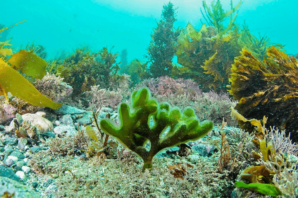
What’s there - The pot is a deep hole with ridges of rock rising from the bottom. The ocean sides of the ridges are covered in growths such as encrusting sponges of various colours and some green hard coral. On the far side of the pot is a small “cave” that you can swim into and surprise the numerous small crabs. There are usually several species of fish, some being visitors that have become trapped as the tide recedes.
The southern bay has seaweed-covered rocks on both sides and the crevices between them offer shelter to a wide variety of fish species such as mado, sweep, rock cale, blue groper, crimson banded wrasse, senator wrasse and luderick. It is not uncommon to come across octopus or stingrays.
Facilities - There is a picnic table beside the parking area. The nearest toilets are close to the Tomakin boat ramp at the end of Kingston Place.
BARLINGS ISLAND
Ability required
Tomakin side – novice;
Burri Pt side - intermediate
How to get there – Turn off George Bass Drive down the dirt track that runs on the Guerilla Bay side of the Barlings Beach caravan park. There is limited parking near the beach.
Conditions - This spot is sheltered from north-east winds and so is a good alternative on summer afternoons when the wind has sprung up. A spit of rocks and sand, that is underwater in most tides, runs out to the island.
What’s there - On the Tomakin side of the spit the bottom is sandy and shallow. Schools of bait fish and mullet can often be seen there. As you near the island there is a bed of strap weed seagrass (Posidonia sp) and rocks covered with low growing seaweeds. Also on the rocks are many large pinkish sea squirts (Herdmania sp) and small urchins can be found in hollows and crevices. Further around the island is an underwater rock scree covered with large seaweeds above and bare rock below low tide mark. The bare rock, or barrens, is deceptive as most of the rocks are covered with pink encrusting coralline algae, the only plants that can withstand the grazing of the numerous large black-spined urchins. If the tide is covering the cunjevoi they will have their paired holes open to filter plankton from the water. Unlike their relatives, Herdmania, they are exposed at low tide so have limited time to feed.
The other side of spit can be more difficult to enter as it is rocky. Once near the island the scene is of vertical rock faces, covered with seaweeds and encrusting animals, with deeper channels between.
Facilities - The nearest toilets are close to the Tomakin boat ramp at the end of Kingston Place.
Barlings Island
TOMAKIN COVE
Ability required – novice
How to get there - Drive to the carpark at the base of Melville Point then walk down the short track on the Tomaga River side of the hill. Or go first to the lookout on top of the point for a birds-eye view of the cove.
Conditions - Tomakin Cove is another relatively sheltered spot that is good for novice snorkelers. The sandy cove is almost completely surrounded by rocky outcrops that shelter it from most directions.
What’s there - Sometimes schools of small whiting, mullet and baitfish can be seen feeding over the sand and small stingarees and eagle rays bury themselves on the bottom. On the seaward side of the cove the dense cover of kelps shelter many small fish and garfish are common in the deeper gutters near Melville Point.
Facilities - The nearest toilets are close to the Tomakin boat ramp at the end of Kingston Place.
BROULEE
SHARK BAY
Ability required – novice
How to get there – From the main road through Broulee turn south into Heath St, left into Bayside St then right into Harbour Drive. Park at the end of Harbour Drive and walk about 200m along the track to the beach.
Conditions - When the north-east wind makes other places too choppy for snorkelling at least one side of Shark Bay is often perfect.
What’s there - The side of the bay nearest to Broulee Island has unusual beds of seagrasses, both eel grass (Zostera sp) and paddle grass (Halophila sp). In summer these may have seahares and the tangled egg strings they lay. You may be fortunate enough to spot one of the catfish that live among the seagrasses or a wobbegong sheltering under a rock. If so, look but do not go too close or provoke these large sharks as they can become aggressive. Along the edge of the rock platform the boulders drop quickly to the sandy bottom. It is worth looking closely and duck-diving to look under overhangs. You are likely to see fish such as ladder-finned pomfret, bulls-eyes and old wives. If you are very lucky you may spot a wobbegong lazing on the bottom. The western side of Shark Bay nearest the headland offers a completely different underwater scene. Near the rock platform is a shallow submerged plateau of boulders interspersed with sand. It has a great variety of seaweeds from large kelps to delicate fronds of red algae and bright green cactus like species. Urchins and turban snails love this habitat. Probably the most numerous fish are rock cale, or rock cockies as they are often called. White-eared and girdled parmas of all ages, mado and sweep are common and you may be lucky enough to come across several fiddler rays resting in one of the sandy hollows or pipe fish drifting among the kelp.
Near the beach the plateau becomes a sandy lagoon great for kids. It often contains small bream, juvenile luderick, mullet, goatfish and numerous toad fish.
On the bay side the plateau drops off suddenly to a sandy bottom and this edge is thickly covered in seaweeds. Senator wrasse, eastern blue groper and the brown females and juvenile gropers seem to prefer this area. It is also home to colourful male crimson-banded wrasse and the reddish females speckled with white. Herring cale are usually seen disappearing among the weed. The brown female is well camouflaged but the dark male with his two irridescent blue tail stripes is quite noticeable. A school or two of the tiny colourful hula fish is likely to be hovering nearby.
Facilities - Toilets and showers are available at the Broulee Surf Club, Heath St.
BROULEE ISLAND
NORTH SIDE
A less accessible sanctuary zone in the BMP.
Ability required - novice, but long walk required.
How to get there –From the main road through Broulee turn south into Heath St, then left into Bayside St. Park at the end of the street and walk about 200m along the track to the beach then along the beach to the island. The Island is a Nature Reserve and the seashore a Sanctuary zone. No fishing or collecting is permitted.
Conditions - In a south or south east wind the north side of Broulee Island can still be good for snorkelling if there is little swell. It is a longer walk from the nearest carpark but there are often interesting things to see washed up on the beach.
What’s there - The shallow sheltered corner where the beach ends is a sandy habitat interspersed with a few rocks. Small fish tend to congregate near the rocks and porcupine fish can usually be seen here. Since Broulee Island is a sanctuary zone with no fishing or collecting permitted, the snorkelling should only improve with time.
Further around the island the rocks enclose two shallow sandy lagoons with seagrass. One has the larger, greener strap weed (Posidonia sp). At higher tides these lagoons are perfect for children learning to snorkel and they will probably see a few small fish among the blades of seagrass.
Shellgrit Bay is bit further around. Drifts of kelp tend to mass near the shore and it can be a bit unpleasant, though harmless, to have to wade through it to begin your snorkel. The bay has a large stand of strap weed and if you take the time and look hard you may see some of the inhabitants of this seagrass. To either side of the bay past the seagrass there are seaweed-covered rocks. Some of the fish frequently seen there are long-finned pike, luderick, yellow-finned bream, drummer, red morwong, rock cale and various wrasses.
Facilities - Toilets and showers are available at the Broulee Surf Club, Heath St.

South Broulee Snorkeler
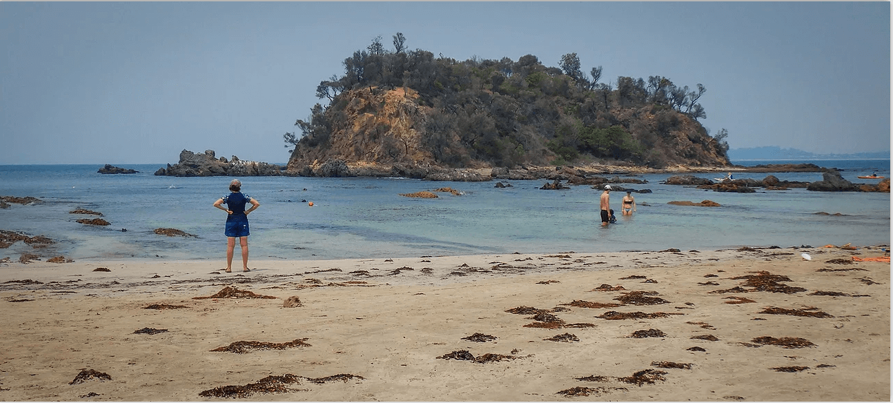
SOUTH BROULEE
Bengelo surf beach
Ability required – experienced
How to get there - When the peak of the holiday season is over, rock-fishers less numerous and, most importantly, seas are very calm, the drop-off along the rock platform at South Broulee is a great place for snorkelling. Park in the Surf Club carpark at the end of Heath St and enter the water at the corner of the beach or from further out on the rock platform. Take great care if entering from the rocks.
Conditions - There is likely to be an outgoing rip current near the rocks but there are several safe places to get out onto the rocks if you find it too strong to swim against going back to the beach.
What’s there - Near the beach shallow sandy areas are interspersed with seaweed-covered rocks. You will usually see schools of small fish such as mado and sweep, and larger fish hiding amongst the weed. Further out the edge of the rock platform has broken off into huge underwater boulders topped with kelps and cunjevoi. Spengler’s tritons, which prey on cunjevoi, are frequently seen dining. Deep crevices between the boulders house black-spined urchins which have grazed the rocks to barrens where no plants grow except the pink encrusting coralline algae. Small territorial fish such as white-eared and girdled parma also live in the crevices, their colourful juveniles looking like tropical fish. Red morwong and schools of yellowtail scad and luderick are often seen near the rocks, and tailor are seasonal visitors. Sea garfish may be schooling just under the water surface.
Facilities - Toilets and showers are available at the Broulee Surf Club and picnic tables are also near the club.
OTHER POSSIBLE SNORKELLING SITES
Murramarang National Park:
North head rock pool and other rocky coves Access via Sth Durras road. The large rock pool is a fascinating place to explore with children, with waves cascading into the pool at high tide. Green hard coral on the walls. But probably have to share it with urchins. Facilities at the nearby camping ground.
Batemans Bay
North shore: Access via Cullendulla Road. Explore Chain Bay, Acheron Ledge, Maloneys beach reefs. Picnic area at Maloneys.
Batehaven area
Sunshine Cove, Denhams Beach, Wimbie Beach, Mackenzie’s Beach (when no surf). Maybe not a lot of fish life but you could be pleasantly surprised. Need to check swell conditions.
Rosedale
Should be sheltered snorkelling near Jimmies Island. Bit of a walk from the carpark. No facilities.
Moruya South Head
Shelly Beach
Snorkel over the shallow reefs to the east and west of the beach. Beware of possible river current in deeper water, at the mouth of the Moruya River. Toilets, beach shower, picnic area with BBQs.
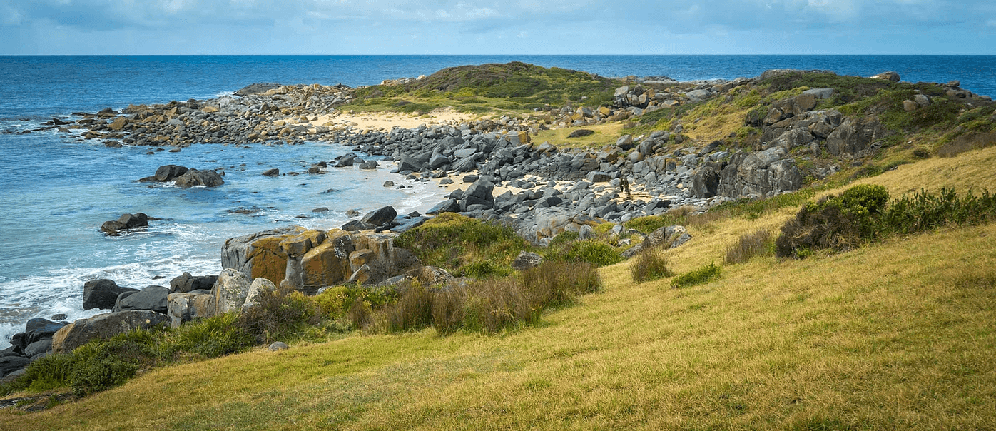
Mullimburra & Bingie Bingie Point
Interesting reefs only accessible in very calm conditions. No facilities.
Dalmeny
Access from boat ramp. Looks like nice sheltered cove. No facilities.
Mystery Bay
Reported to be good snorkelling over lots of reefs. Some fantastic variations in kelp species.
Should be some shelter in most weathers. Camping facilities.

Fun at Mystery Bay
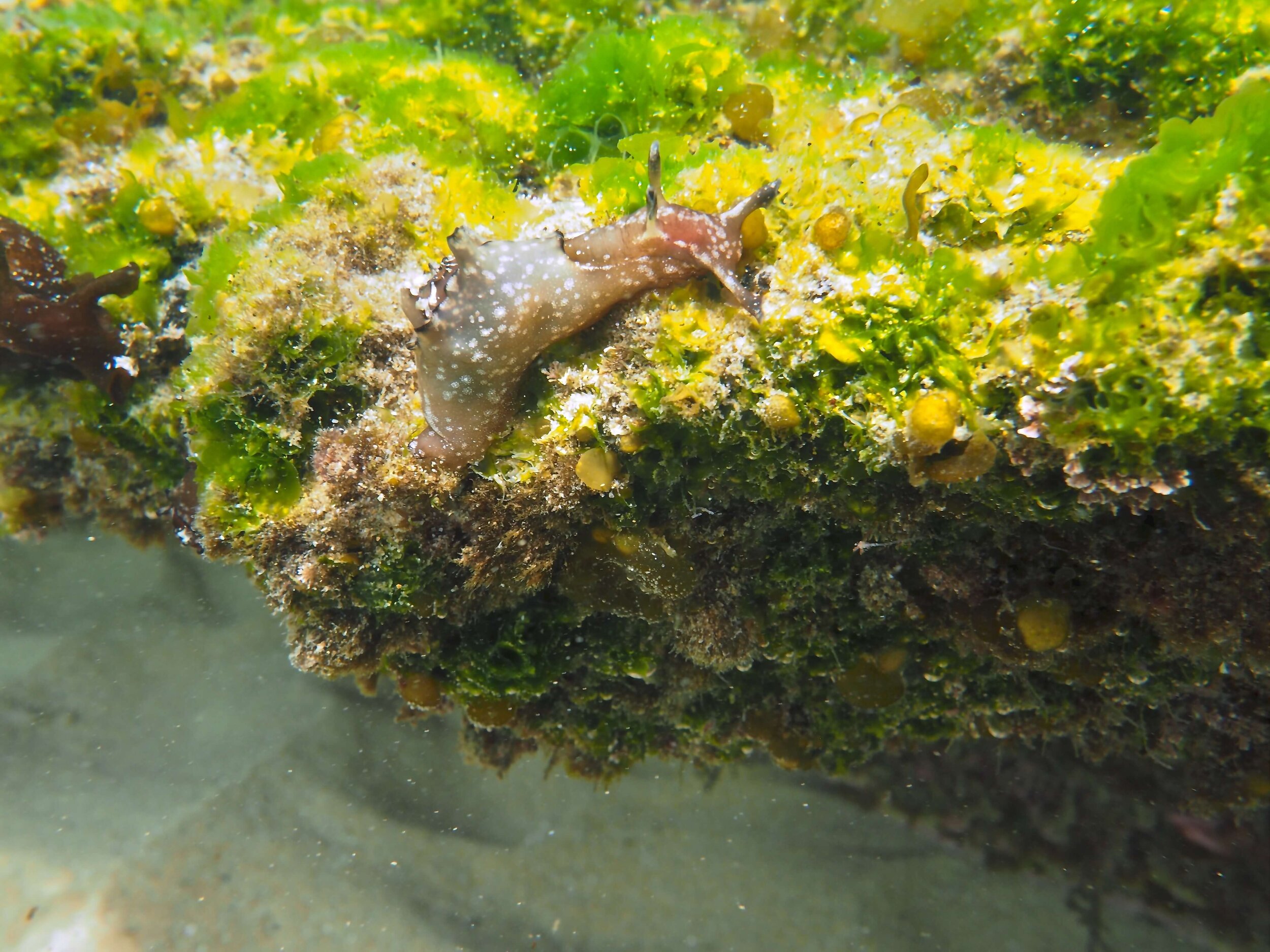
Sea Hare, Mystery Bay
POTATO POINT
Ability required – experienced
How to get there – From Potato Point Road take the turn to the boat ramp and park beside the road.
Conditions – Potato Point is fairly exposed and is not good for snorkelling if the swell is more than a metre or if the wind is coming from the north or north-east. The easiest entry is from the boat ramp though snorkelers need to be aware of the rip current there. This is fine for helping you get away from the beach, but it can make it difficult if not impossible to exit the water close to the boat ramp. The best exit is to swim parallel to the beach for 20 or 30 metres, at which point the snorkeler can return to the beach through the surf. Snorkelers also need to be aware of the small amount of boat traffic in the area. This is best dealt with by keeping close to the rocks near the boat ramp and keeping a careful watch.
What’s there - With rocky reef bommies interspersed with sandy gutters, Potato Point can be an exciting place to snorkel. A variety of habitats, including kelp forests, turfing algae, urchin barrens, sandy bottoms and cunjevoi, support an interesting range of marine life. Reef fish may be found in abundance, including rock cale, herring cale, kelp fish, blue groper and other wrasses, white ears, mado, silver sweep, leatherjackets, moray eels and luderick. Over the sand flats will be seen long finned pike, yellowtail, bream and toadfish. It is not uncommon to see large stingrays, eagle rays, fiddler rays and smaller stingarees. From time to time the snorkeler might even see schools of salmon or kingfish, as well as Port Jackson sharks or wobbegongs. In shallower water there are many juvenile fish and the occasional octopus, cuttlefish or squid.
Facilities - There is a toilet in the reserve between the creek and Riverview Drive, and a cold shower available at the boat ramp.
NAROOMA BAR BEACH
This is an ideal place for family or novice snorkelEr
Ability required – Within the net - novice; Outside the net – intermediate
How to get there – On the northern side of Wagonga Inlet, follow Centenary Drive to the large parking area near the boat ramp.
Conditions – Bar Beach is well sheltered and so is a reliable place in almost any weather. The water is calm and is usually very clear. The site comprises a sandy beach bordered on one side by an artificial rock wall and with a net extending from the wall in an arc back to the beach.
Entrance and exit from the beach is very easy. Snorkelers should be aware of the tidal current, though this is not a problem inshore. Snorkelers should also be careful around the net and, because of the danger of entanglement, NEVER duck dive under it.
What’s there – Within the net: Because of the strong tidal current than pushes in and out of the inlet twice a day, there is a good variety of fish and other marine creatures. Juvenile luderick feed from the net while fan-bellied leatherjackets look on. Swimming over the sand will be bream, mullet and whiting. Along the rock wall snorkelers will see a good range of reef fish, often juveniles, including blue groper and other wrasses, mado, sweep, white ears, red morwong. Further along the wall the water becomes deeper and snorkelers are likely to see drummer, long-finned pike and leatherjackets. Snorkelers are sometimes surprised to see octopus, sea hares, nudibranchs and even the occasional sea horse on the net.
Outside the net: Experienced snorkelers can explore the rock wall at the upstream end of the beach where a good range of fish may also be found. Keep out of the current in the channel, watch for boat traffic and keep close to the shore.
Facilities - There is a toilet block near the boat ramp and an outdoor shower near the access point to the beach.
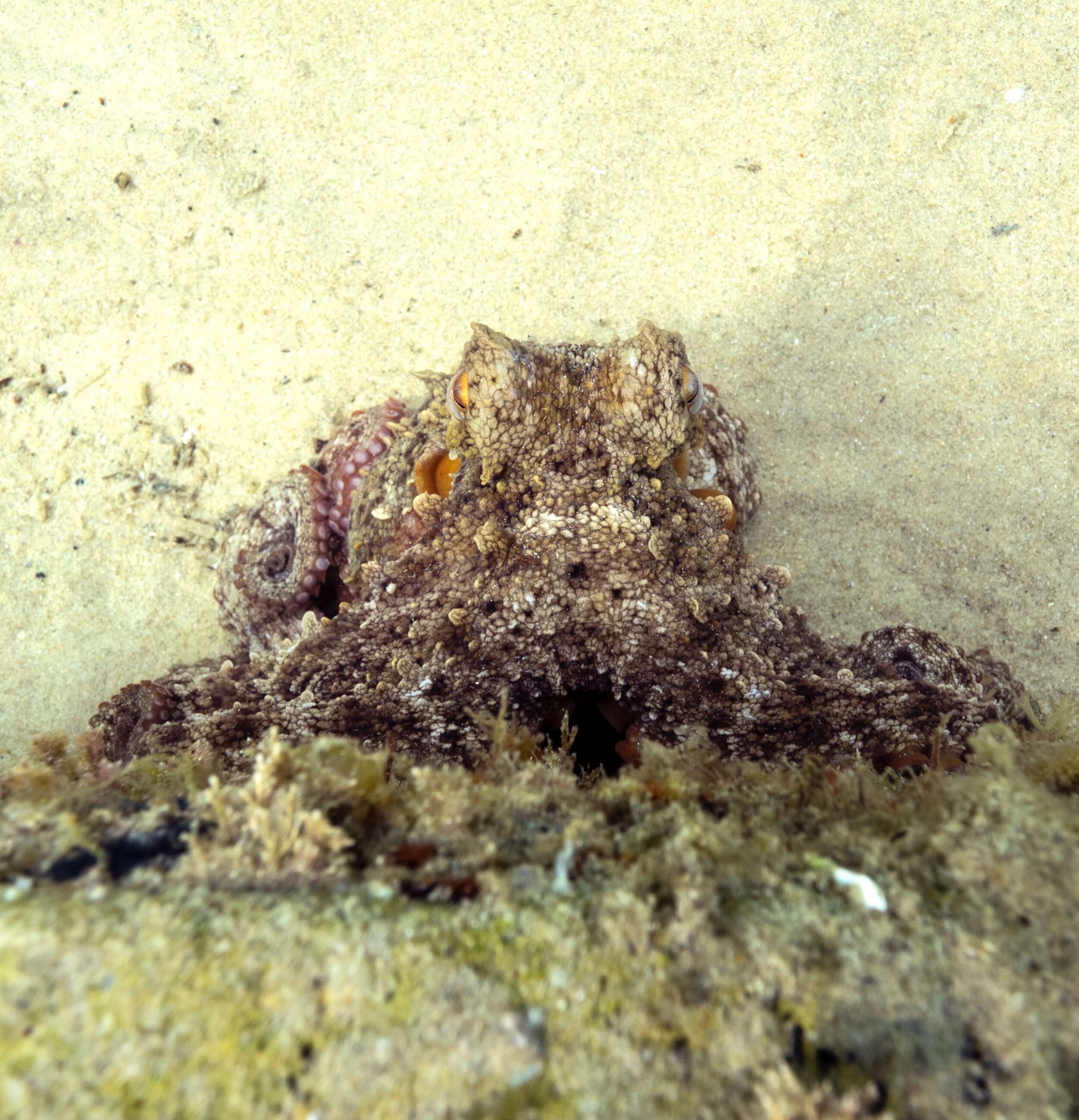
Occie at Bar Beach by Catfish Creative
MONTAGUE ISLAND
a boat trip for the more experienced
The highlight of snorkelling at Montague Island is to be in the water with the resident fur seals. This is a thrilling wildlife encounter on a par with anything that may be found elsewhere in the world.
Ability required – experienced
How to get there - Obviously it requires a boat trip to visit the island. Several Narooma charter operators cater for snorkelling trips to the island, and will provide detailed briefings and instructions to ensure that snorkelers have a safe and enjoyable time. The trip will usually involve snorkelling at several different sites. The Nature Coast Marine Group organizes one or two trips to Montague Island each year to snorkel with the seals.
Conditions - Anyone snorkelling at Montague Island should be properly equipped, including a good wetsuit. Charter operators will hire out all gear. While the snorkelling sites are usually sheltered, the trip across to the island can sometimes be rough, so those who are prone to seasickness would be well advised to take appropriate medication an hour or two before departure. It is too late once you start feeling queasy, and the rest of your day will be ruined!
What’s there - The snorkeler can be very close to numbers of playful seals as they swim effortlessly around, up and down, sometimes hurtling towards the observer and then turning away at the last minute. Their underwater acrobatics is both beautiful and amazing as they move through the water trailing a line of air bubbles. They will often imitate your own antics so try a few somersaults! In addition, their appealing and intelligent faces are highly photogenic. While the seals are very playful it must always be remembered that they are wild animals and the snorkeler should never attempt to touch them. Nor should snorkelers attempt to clamber on the rocks where they are resting. It is said that their temperament is quite different on land and it is illegal to go ashore unauthorised on the island.
In addition to the seals, Montague Island offers a dramatic location for snorkelling among massive boulders and a rich marine life.

Photo by Underwater Safaris
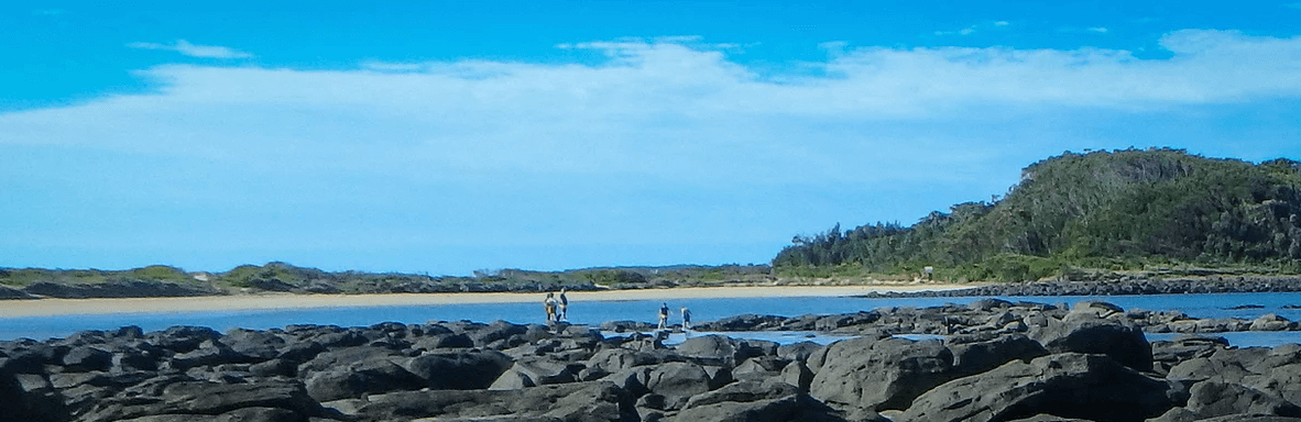
Bingie Bingie Point

Southern Eagle Ray, Narooma
Shark Bay, Broulee